
It is lovely to know that there is a shelter waiting for you at the end of a long day walking across the wilderness. In New Zealand there is a large network of serviced huts dotted all over the hiking trails. Some of these need to be booked in advance (like Angelus Hut) others are on a first come first serve basis. Angelus hut is a beautiful, remote, well serviced hut with outside toilets and a log burning fire. There are several routes into the hut. I took the Robert Ridge route in and the Speargrass route out. The total distance was 22k and total elevation was 1,613. These stats come from my watch – we had to take several detours which I will explain below.. It is a long read!
Day 1: Mt Robert Car Part to Angelus Hut
I did this walk on the 17th October, which is early spring. The recommended window for this walk is from November onwards therefore I was not certain about what conditions would be at the top. I did ask at the visitor centre in St Anaud and they were not sure as the cameras were out of action.
I packed:
| Overnight items | Food | Equipment | Clothes |
|---|---|---|---|
| Sleeping bag | Real Meals x 2 | Hiking poles | Waterproof Jacket & trousers |
| Thermal liner | Trail mix / Scroggin | Map – paper | Hat |
| Toothbrush & paste | Fizzy worms (sour) | Garmin GPSmap – | Mittens, fingerless, – made of wool. Terrible choice. Should have had waterproof or insulated gloves |
| Jet Boil | 1.5l of water | Garmin InReach (satellite connected device for messages & weather reports) | Thin thermal top layer |
| Tin mug & fork | Wool jumper | ||
| Pyjamas & warm socks | Big puffy down jacket (which packs down tiny if you squish it) |
I wore trail running shoes as they were the only shoes I had with me in NZ. Hiking boots, and even crampons or micro spikes would have been better.
Part 1 – Up Pinchgut
The first part of the route is called ‘Pinchgut’ and it is a steep switch back trail through woodland, leading up to the ridge line and a small shelter called ‘Relax Shelter’.
What I loved about this trail, is that you got all the elevation out of the way at the beginning. Most of the rest of the trail was ridge and scrambling with expansive views on both sides.
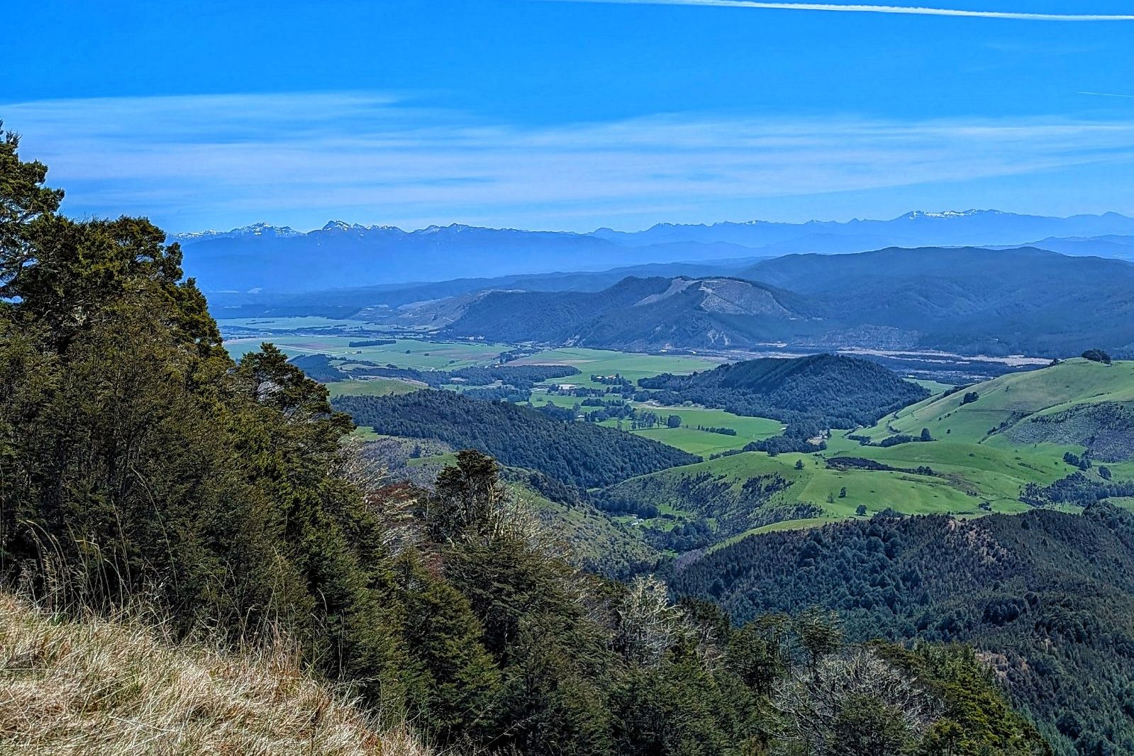
Part 2 – Along the ridge
This section was a delight. On a clear day (which we had) you can see distant ranges on both sides of you. The snow on the peaks added an extra level of beauty and helped get a sense of scale. The first part of the ridge was easy going. The path was broad, and there were only a few areas where snow covered the track and we had to detour, scrambling over boulder fields to get across. We reached Flagpole, which is the halfway point of the walk and took a moment to enjoy the view.
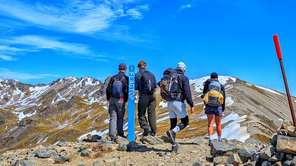
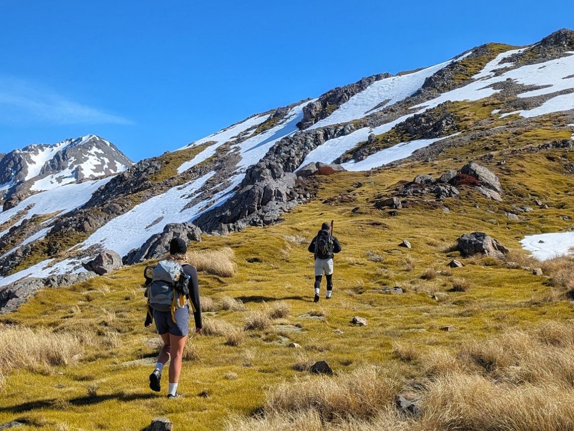
After ‘Flagpole’ things got a little more tricky as the main path was covered in snow, and we needed to scramble across exposed rock, or kick our way through the ice / snow. Having hiking poles made the snow crossings much easier as they provided additional points of contact on the mountain. I am not a brave scrambler and this section of ridgeline challenged my courage but it was more than doable.
Part 3 – The approach to Angelus Hut
Descending from the ridge, we were met with a few final patches of snow to traverse. We could see up ahead that several had gone before us, and that some had fallen and taken a slide before stopping. We identified a clear shoulder of grassy rock that seemed to connect back to the main trail and would allow us to avoid the ice/snow hazard.
Once reaching the highest point, you are rewarded with a view down to Angelus lake, and Angelus Hut nestled inside. You need to follow the path markers around to your left, circling the crater a little, to access a safer way down to the hut. The seemingly more direct route is just a scree slope and not recommended.
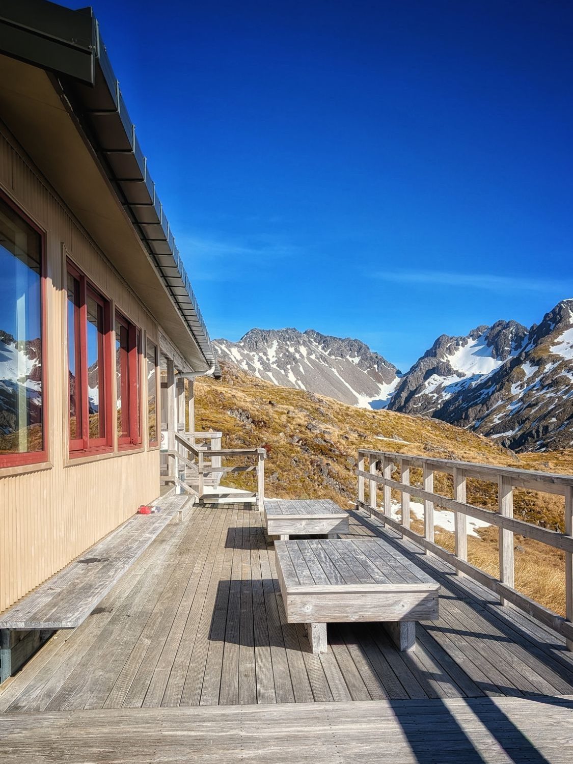
Angelus Hut:
28 bunks split into two rooms. There are several large dining tables, a kitchen area with stainless steel counter tops, an outdoor woodshed, rainwater tank near the entrance and a compostable loo set back at a fair distance from the hut (to reduce the smell!).
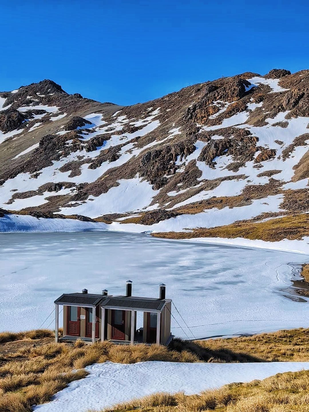
There is also a big decking that wraps around the hut, and in Summer I imagine it would be a great place for a swim and sunbathe. The lake was iced over in October however, and there was not enough wood to make a decent fire therefore not even the bravest hut dwellers went for a dip.
For my first hut experience – this was excellent. There was one lady there who warned me that they are not all like this.. and I later found this to be very true.
Day 2: Return from the Hut via Speargrass
Part 1 – Exiting the Alpine region
The morning dawned misty and cold. Our route out followed the path markers back up to the ridge, back down our grassy shoulder, then across a patch of snow which had hardened into ice in the night. The slope was shallow, therefore there was no real danger if we had slipped at this stage. We had very low visibility however, therefore it was good that we had learned the route the day before.

There is a short ascent to gain the ridge line, meeting Robert Ridge then taking a left fork and heading steeply downhill. The going is easy, with a clear path, grassy tufts and rocks until you leave the snow line and freezing temperatures behind. I was glad of this, as my fingerless mittens did nothing to stop my fingers freezing in the wind as we were making our way out from the hut. I did not complain, but gave myself a stern note for the future not to climb an icy mountain in fingerless fashion gloves ever again.
Part 2 – The river
Here follows a number of river crossings and scree filled descents where parts of the path have been destroyed through landslip. It is not exactly difficult, but it is trying. I was pleased to be descending this way, as ascending it would have been demoralising as I imagine for every 4 steps uphill you would slide 1 step back on the loose rocks.
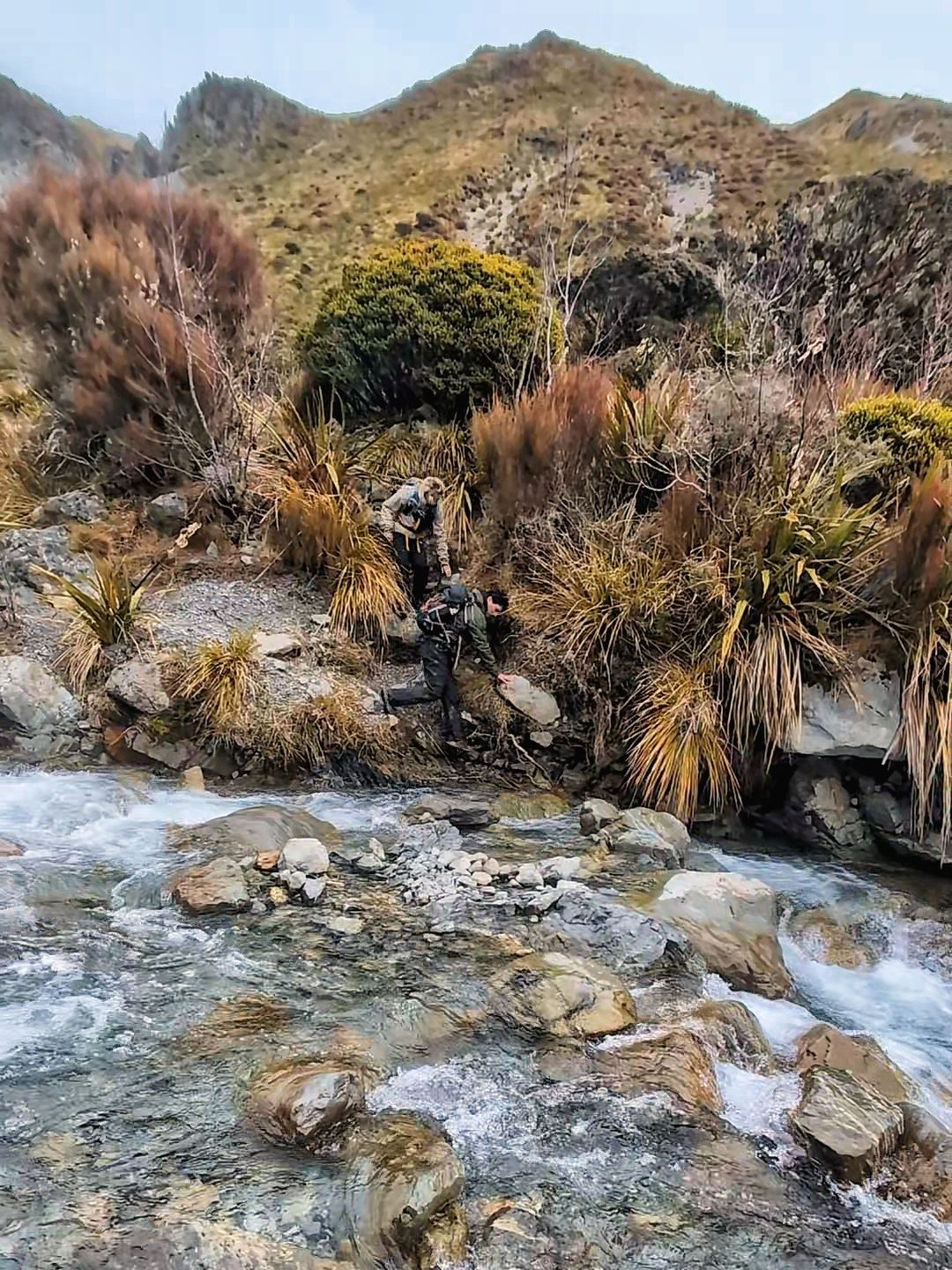
Not a single member of my group (3 of us) managed to complete the river crossings without getting wet. One person made it to the second to last one before slipping on a stone. We also met a hiker who had fallen into the river and was cold, wet, and miserable. The river was shallow, reaching only to knee height at the deepest crossing. It was quite fast flowing so it required careful attention to footing, but if you had fallen in, the worst that would happen is that you would be wet and cold – you would not be swept completely away.
Part 3 – The forest
After leaving the river behind you re-enter the woods for the final stretch. Here too, you will pass another hut, the Speargrass hut’ where you could stop to rest, eat, or even sleep if you had had enough of tramping with wet feet by this point.
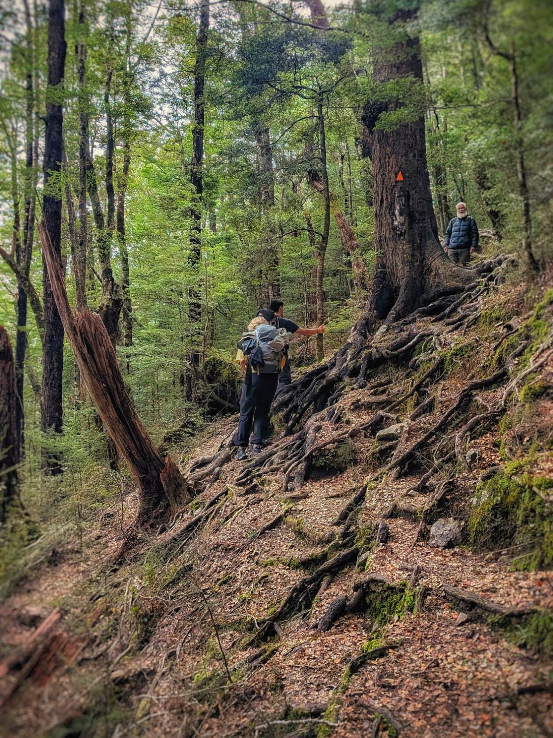
The forest is dense, and the path requires much care. There are roots everywhere, sometimes adding steps, sometimes being used as hand holds to hoist yourself up a level but at all times representing a trip hazard.
Summary
The Department of Conservation in New Zealand manages over 950 huts across the country. These vary greatly in services and standards. Research the hut you are going to on the website as it will tell you what to expect in each case. I have found that the larger huts seem to be better. I have visited 2, 8 and 28 bunk huts so far.
Each one requires that you bring all essentials (cooking, sleeping, eating, toiletries). The main difference is that some have fires, flushing loos (very few), and more space to sit around and talk as a group. Some seem much more like shelters for hunters or people who get suck outside rather than a ‘destination’.
Angelus hut is one of the larger ones. It has a beautiful decking area which is a complete sun trap in the afternoon, a lake for swimming and a wood fire (although there was no wood when I went). I would definitely go back again however, given there are 900+ other huts to explore, I doubt that I will ever return to this one.
Discover more from The Little Hiker's Guide
Subscribe to get the latest posts sent to your email.
